
0
INQUIRY
enquiry form:
Inquiry Content:

You have no items to require
-
 English
-
Polski
-
فارسی
-
Dansk
-
Deutsch
-
Русский язык
-
Français
-
қазақ
-
한국어
-
Nederlands
-
Hrvatska
-
Latina
-
norwegian
-
Português
-
日本語
-
Svenska
-
Srpski@ item Spelling dictionary
-
Slovenská
-
slovenščina
-
Türkçe
-
УкраїнськаName
-
o'zbek
-
Español
-
Magyar
-
Արմենյան
-
Italiano
-
IndonesiaName
-
Tiếng Việt
-
عربي
-
Íris
-
Български
-
ÍslandName
-
suomi
-
Čeština
-
română
-
Malay
-
ภาษาไทย
-
Ελληνικά
 English
 Polski
 فارسی
فارسی
 Dansk
Dansk
 Deutsch
 Русский язык
 Français
 қазақ
қазақ
 한국어
한국어
 Nederlands
 Hrvatska
 Latina
 norwegian
 Português
 日本語
日本語
 Svenska
 Srpski@ item Spelling dictionary
 Slovenská
 slovenščina
 Türkçe
 УкраїнськаName
 o'zbek
 Español
 Magyar
 Արմենյան
 Italiano
 IndonesiaName
 Tiếng Việt
 عربي
عربي
 Íris
Íris
 Български
 ÍslandName
 suomi
suomi
 Čeština
 română
 Malay
Malay
 ภาษาไทย
 Ελληνικά
How GNSS RTK Handheld Technology is Transforming Field Surveying and Mapping
2026-03-25 17:15:43
Click:
“
GNSS RTK handheld devices are transforming modern surveying and geospatial data collection by delivering real-time, centimeter-level positioning accuracy. By leveraging multi-constellation satellite systems such as GPS, BeiDou, Galileo, and QZSS, along with CORS network corrections, these devices significantly improve measurement precision and operational efficiency.
This article explores the core principles of RTK technology, its advantages over traditional GPS, and its key applications in lan
”
In modern surveying and geospatial industries, accuracy and efficiency are critical. Traditional GPS devices often struggle to deliver the precision required for professional applications. With the advancement of GNSS RTK (Real-Time Kinematic) technology, handheld devices are now capable of achieving centimeter-level accuracy, revolutionizing field data collection and mapping workflows.
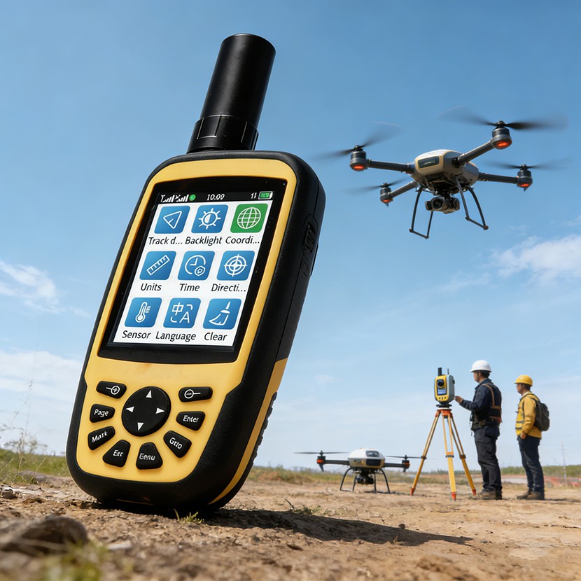
What is GNSS RTK Technology?
GNSS RTK is a high-precision positioning technology that enhances satellite navigation accuracy by using real-time correction data from base stations or CORS (Continuously Operating Reference Stations). By combining signals from multiple satellite systems such as GPS, BeiDou, Galileo, and QZSS, RTK significantly reduces positioning errors.
This allows users to achieve 1–2 cm accuracy, which is essential for applications like land surveying, construction layout, and GIS data acquisition.
Key Advantages of RTK Handheld Devices
1. Centimeter-Level Accuracy in Real Time
Unlike standard GPS devices with meter-level accuracy, RTK-enabled handhelds provide real-time corrections, ensuring precise positioning even in complex environments.
2. Multi-Constellation Signal Support
Modern devices support multiple satellite systems simultaneously, improving signal availability and stability, especially in urban or mountainous areas.
3. Integrated 4G and CORS Connectivity
With built-in 4G modules, RTK handheld devices can directly connect to CORS networks, eliminating the need for additional base stations and simplifying field operations.
4. Efficient Data Collection and Management
Field data such as points, lines, and polygons can be collected, stored, and exported in formats like CSV, GPX, and CAD, making it easy to integrate with GIS and mapping software.
Application Scenarios
Land Surveying and Mapping
RTK handheld devices enable surveyors to quickly measure land boundaries, calculate areas, and generate accurate maps without bulky equipment.
Construction and Engineering
Precise positioning is essential for site layout, elevation measurement, and infrastructure development. RTK technology ensures high accuracy and reduces rework.
GIS Data Collection
Professionals can collect geospatial data with high precision, supporting urban planning, environmental monitoring, and asset management.
Agriculture and Forestry
RTK positioning helps optimize precision farming, land management, and forestry surveys by providing accurate geographic data.
Recommended Solution: QM320R GNSS RTK Handheld Device
The QM320R is a next-generation GNSS RTK handheld device designed to meet the demands of professional users. It integrates:
- Multi-constellation GNSS (GPS, BeiDou, Galileo, QZSS)
- Real-time RTK positioning with 1–2 cm accuracy
- Built-in 4G, WiFi, and Bluetooth connectivity
- Support for multiple coordinate systems (WGS84, UTM, CGCS2000, etc.)
- Advanced measurement functions including area, distance, and elevation analysis
- Cloud synchronization for efficient data management
Its compact design, long battery life, and rugged IP65 protection make it ideal for various outdoor environments.
Conclusion
GNSS RTK handheld devices are transforming how professionals perform surveying and mapping tasks. By combining high precision, portability, and real-time connectivity, these devices significantly improve efficiency and accuracy in the field.
As industries continue to demand better geospatial data, adopting advanced RTK solutions like the QM320R will become essential for staying competitive and delivering reliable results.
Author:
Starmax International Technology Co., Limited


文章推荐
Smart Mining Communication & High-Precision Positioning Solutions
Why LTE Push-to-Talk Radios Are Replacing Traditional Walkie Talkies in Industrial Operations
How Rugged Android Smart Radios Are Transforming Industrial Communication in 2026
How Rugged Android Smart Radios Are Transforming Industrial Communication
XM240T Rugged Android Smart Two-Way Radio with GPS & NFC for Professional Field Communication
Follow Us

点击右上角
分享给朋友吧
Copyright © 2015-2035 MySite Ltd. All Rights Reserved.
 Service1
 Service2
 Service3