
0
INQUIRY

enquiry form:

  • Please enter the verification code

Inquiry Content:


You have no items to require

XM200R High-Precision RTK Portable Positioning Terminal

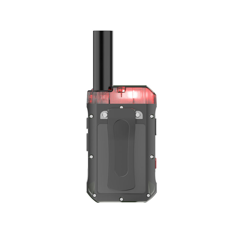
The XM200R is a professional‑grade portable tracker built for high‑accuracy location monitoring. It supports RTK and multi‑mode GNSS positioning, Beidou III signal system (B1C, B2A),4G CAT1 communication, NFC functionality, and features IP67 protection—making it ideal for precision tracking in logistics, lone worker safety, field operations, and other demanding outdoor environments.

XM200R High-Precision RTK Portable Positioning Terminal

Select the number of specifications

Please check the product information you want!

Product Detail

XM200R High-Precision GNSS RTK Positioning Terminal | Starmax International
HIGH-PRECISION GNSS RTK TERMINAL

XM200R High-Precision GNSS RTK Positioning Terminal

Engineered for professionals who demand sub-meter to centimeter-level positioning accuracy, multi-constellation GNSS support, and reliable performance in challenging outdoor environments. Ideal for UAV, precision agriculture, autonomous machines, surveying, and GIS mapping.

Sub-meter / RTK Accuracy
GPS · BeiDou · GLONASS · Galileo
4G CAT1 Connectivity
IP67 Rugged Protection
Compact & Lightweight
Long Battery Life
<1mHorizontal Accuracy
IP67Industrial Grade
6Constellations
3000mAhBattery
Starmax XM200R GNSS RTK Terminal

Built for Precision. Engineered for Reliability.

The STARMAX XM200R High-Precision GNSS RTK Positioning Terminal combines advanced multi-constellation satellite positioning, 4G CAT1 communication, and industrial-grade durability into a compact, lightweight solution. Designed for UAV navigation, precision agriculture, autonomous machines, surveying, and GIS mapping, XM200R delivers dependable sub-meter to centimeter-level positioning performance wherever precision matters.

XM200R RTK Terminal detailed view

Professional GNSS Positioning Solution

Powered by advanced GNSS technology, XM200R supports GPS, BeiDou, GLONASS, Galileo, QZSS and SBAS multi-frequency positioning, with optional RTK for centimeter-level accuracy. Its compact size and low power consumption make it ideal for integration into UAVs, autonomous vehicles, and portable survey equipment.

With IP67 protection, wide operating temperature range, and flexible communication options (UDP/TCP, 4G CAT1), XM200R ensures reliable data transmission and positioning in harsh field conditions.

  • Sub-meter (Single Point) / Centimeter (RTK) Accuracy
  • GPS + BeiDou + GLONASS + Galileo + QZSS + SBAS
  • 4G CAT1 & UDP/TCP Communication
  • IP67 Waterproof & Dustproof
  • Compact 100×60×20 mm, 80g
  • Ideal for UAV, Agriculture, Surveying & Autonomous Systems

<1 m

RTK Horizontal Accuracy

6

Satellite Systems

IP67

Industrial Protection

80 g

Ultra Lightweight
📡

High-Precision Positioning

RTK engine provides sub-meter to centimeter-level positioning for surveying, mapping, and autonomous navigation.

🌍

Multi-Constellation GNSS

Supports GPS, BeiDou, GLONASS, Galileo, QZSS and SBAS for maximum signal availability and reliability.

🛡

Industrial Rugged Design

IP67 protection and reinforced housing withstand rain, dust, vibration, and harsh outdoor conditions.

Low Power & Compact

Ultra-compact form factor and low power consumption enable easy integration into UAVs, robots, and portable devices.

Six Powerful Features for Precision Applications

XM200R integrates advanced RTK positioning, multi-constellation GNSS, 4G connectivity, and rugged design into a compact terminal. Built for professionals working in demanding environments, it delivers reliable sub-meter to centimeter-level positioning and seamless data transmission.

📡

RTK Centimeter Accuracy

Professional RTK engine provides sub-meter to centimeter-level positioning with rapid initialization for surveying, UAV navigation, and precision agriculture.

Learn More →
🛰️

Multi-Constellation GNSS

Supports GPS, BeiDou, GLONASS, Galileo, QZSS and SBAS to maximize satellite visibility and positioning reliability.

Learn More →
📶

4G CAT1 & TCP/UDP

Integrated 4G CAT1 module with UDP/TCP protocol support enables real-time data transmission for remote monitoring and control.

Learn More →
🛡️

IP67 Rugged Protection

Designed for harsh outdoor environments with waterproof, dustproof, and shock-resistant construction that meets industrial standards.

Learn More →

Low Power & Compact

Ultra-compact size (100×60×20mm) and lightweight (80g) with low power consumption, ideal for UAV, robotics, and portable applications.

Learn More →
🌍

Multiple Industry Applications

Ideal for precision agriculture, surveying, UAV navigation, autonomous machines, GIS mapping, and infrastructure monitoring.

Learn More →

Interactive Product Explorer

Hover over any hotspot or click on a component to learn more about the key features of XM200R.

XM200R
GNSS Antenna
4G CAT1 Module
NFC & RFID
SOS Button
High-Capacity Battery
IP67 Waterproof

Key Components

  • GNSS AntennaMulti‑frequency high‑gain
  • 4G CAT1 ModuleUDP/TCP real‑time
  • NFC & RFIDContactless data exchange
  • SOS ButtonEmergency alert
  • High‑Capacity Battery3000mAh lithium
  • IP67 WaterproofDust & water sealed

Sub-Meter to Centimeter-Level Positioning

The XM200R leverages advanced Real-Time Kinematic (RTK) technology to deliver sub-meter to centimeter-level positioning accuracy, enabling precise navigation, surveying, and automation applications with rapid initialization and high reliability.

RTK
1

Multi-Constellation Signal Tracking

XM200R tracks GPS, BeiDou, GLONASS, Galileo, QZSS and SBAS satellites simultaneously, ensuring maximum satellite visibility and robust signal reception even in challenging environments.

2

Real-Time Correction Processing

Onboard RTK engine processes correction data from base stations or network services (NTRIP) to compute precise positioning with sub-meter to centimeter-level accuracy.

3

Fast & Reliable Initialization

Advanced algorithms ensure rapid RTK fix initialization with high reliability, minimizing downtime and maximizing productivity in the field.

4

Precision Output

Delivers horizontal accuracy better than 1 m CEP in RTK mode, meeting the most demanding requirements for UAV navigation, agriculture, and surveying.

Versatile Across Industries

XM200R is engineered to perform in a wide range of professional applications, from precision agriculture and UAV navigation to surveying and autonomous systems. Its compact size and high-precision GNSS make it the ideal tool for field professionals and system integrators.

🚁

UAV & Drone Navigation

High-precision RTK positioning for autonomous flight, mapping, and inspection applications.

🌾

Precision Agriculture

Field boundary mapping, crop health monitoring, and precision guidance for farm equipment.

🗺️

Surveying & GIS Mapping

Accurate ground control points, asset mapping, and topographic surveys with sub-meter accuracy.

⛏️

Mining & Quarrying

Volume calculation, blast pattern design, and pit mapping in demanding and dusty environments.

📊

GIS & Asset Management

Infrastructure asset tracking, utility mapping, and environmental monitoring with high-accuracy GNSS.

🤖

Autonomous Vehicles

Navigation and positioning for agricultural robots, automated guided vehicles (AGVs), and industrial automation.

Global Satellite Coverage

XM200R supports all major global navigation satellite systems, providing robust positioning performance in any region and environment.

🇺🇸

GPS

L1 C/A, L2C, L2P(Y), L5

Global Positioning System – full support

🇨🇳

BeiDou

B1I, B2I, B3I, B1C, B2a, B2b

Chinese satellite navigation system

🇪🇺

Galileo

E1, E5a, E5b, E6

European global navigation system

🇷🇺

GLONASS

G1, G2, G3

Russian global navigation system

🇯🇵

QZSS

L1, L2, L5, L6

Japanese regional augmentation system

🌐

SBAS

WAAS, EGNOS, MSAS, GAGAN, SDCM

Satellite-based augmentation systems

Works with Your Tools

XM200R is compatible with a wide range of professional surveying, mapping, and GIS software, ensuring seamless integration into your existing workflow.

🗺️

QGIS

Open-source GIS

🗺️

ArcGIS

Professional GIS platform

📐

AutoCAD

CAD & engineering design

🌍

Google Earth

3D visualization & mapping

📊

CSV / GPX

Data exchange formats

📡

NMEA 0183

Standard GNSS protocol

Detailed Specifications

Comprehensive technical data for the XM200R High-Precision GNSS RTK Positioning Terminal. Click on each category to expand.

General+
Dimensions100 × 60 × 20 mm
Weight80 g (including battery)
Protection ClassIP67 (waterproof & dustproof)
Drop Resistance1.2 meters
GNSS Performance+
Satellite SystemsGPS, BeiDou, GLONASS, Galileo, QZSS, SBAS
Positioning Accuracy (RTK)Horizontal < 1 m CEP
Positioning Accuracy (Single Point)Horizontal < 1.5 m CEP (with DGPS)
SensitivityBetter than -162 dBm (tracking)
Reacquisition Sensitivity-158 dBm
Time Accuracy1PPS 20 ns
Speed Accuracy0.1 m/s CEP
Communication+
ProtocolsUDP / TCP (customizable)
4G CAT1 BandsFDD: B1/3/5/8; TDD: B34/38/39/40/41
NFCSupports NFC card punching, personnel information
Optional ModulesWiFi, Bluetooth
Battery & Power+
TypeLithium polymer, 3000 mAh / 3.7V
Operating Voltage3.8V
Working Current300 mA
Standby Current< 5 mA
Physical & Environment+
Operating Temperature-20°C to +70°C
Storage Temperature-30°C to +85°C
IndicatorsRed – charging/low battery/PPT; Green – fully charged/GPS; Blue – communication; Yellow – WiFi; Orange – BT
SensorsG-Sensor, Gyroscope

Resources & Downloads

Access product manuals, SDKs, firmware updates, and other essential resources for the XM200R.

📄

Datasheet

Complete specifications

Download PDF
📘

User Manual

Setup & operation guide

Download PDF
⚙️

SDK

Development kit

Download ZIP
📦

Firmware

Latest version

Download
📜

Certificate

Compliance & test reports

Download PDF

Frequently Asked Questions

Find answers to the most common questions about the XM200R High-Precision GNSS RTK Positioning Terminal.

Need Professional Positioning?

Contact STARMAX today for expert advice, pricing, or to request a demo of the XM200R. Our team is ready to help you find the ideal high-precision GNSS solution for your project.

Get a Quote

Fill in your details and we'll respond within 24 hours.

© 2026 Starmax International Technology Co., Limited. All rights reserved.

Precision Positioning · Intelligent Connectivity · Rugged Innovation

No comment

Product Detail
XM200R High-Precision GNSS RTK Positioning Terminal | Starmax International
HIGH-PRECISION GNSS RTK TERMINAL

XM200R High-Precision GNSS RTK Positioning Terminal

Engineered for professionals who demand sub-meter to centimeter-level positioning accuracy, multi-constellation GNSS support, and reliable performance in challenging outdoor environments. Ideal for UAV, precision agriculture, autonomous machines, surveying, and GIS mapping.

Sub-meter / RTK Accuracy
GPS · BeiDou · GLONASS · Galileo
4G CAT1 Connectivity
IP67 Rugged Protection
Compact & Lightweight
Long Battery Life
<1mHorizontal Accuracy
IP67Industrial Grade
6Constellations
3000mAhBattery
Starmax XM200R GNSS RTK Terminal

Built for Precision. Engineered for Reliability.

The STARMAX XM200R High-Precision GNSS RTK Positioning Terminal combines advanced multi-constellation satellite positioning, 4G CAT1 communication, and industrial-grade durability into a compact, lightweight solution. Designed for UAV navigation, precision agriculture, autonomous machines, surveying, and GIS mapping, XM200R delivers dependable sub-meter to centimeter-level positioning performance wherever precision matters.

XM200R RTK Terminal detailed view

Professional GNSS Positioning Solution

Powered by advanced GNSS technology, XM200R supports GPS, BeiDou, GLONASS, Galileo, QZSS and SBAS multi-frequency positioning, with optional RTK for centimeter-level accuracy. Its compact size and low power consumption make it ideal for integration into UAVs, autonomous vehicles, and portable survey equipment.

With IP67 protection, wide operating temperature range, and flexible communication options (UDP/TCP, 4G CAT1), XM200R ensures reliable data transmission and positioning in harsh field conditions.

  • Sub-meter (Single Point) / Centimeter (RTK) Accuracy
  • GPS + BeiDou + GLONASS + Galileo + QZSS + SBAS
  • 4G CAT1 & UDP/TCP Communication
  • IP67 Waterproof & Dustproof
  • Compact 100×60×20 mm, 80g
  • Ideal for UAV, Agriculture, Surveying & Autonomous Systems

<1 m

RTK Horizontal Accuracy

6

Satellite Systems

IP67

Industrial Protection

80 g

Ultra Lightweight
📡

High-Precision Positioning

RTK engine provides sub-meter to centimeter-level positioning for surveying, mapping, and autonomous navigation.

🌍

Multi-Constellation GNSS

Supports GPS, BeiDou, GLONASS, Galileo, QZSS and SBAS for maximum signal availability and reliability.

🛡

Industrial Rugged Design

IP67 protection and reinforced housing withstand rain, dust, vibration, and harsh outdoor conditions.

Low Power & Compact

Ultra-compact form factor and low power consumption enable easy integration into UAVs, robots, and portable devices.

Six Powerful Features for Precision Applications

XM200R integrates advanced RTK positioning, multi-constellation GNSS, 4G connectivity, and rugged design into a compact terminal. Built for professionals working in demanding environments, it delivers reliable sub-meter to centimeter-level positioning and seamless data transmission.

📡

RTK Centimeter Accuracy

Professional RTK engine provides sub-meter to centimeter-level positioning with rapid initialization for surveying, UAV navigation, and precision agriculture.

Learn More →
🛰️

Multi-Constellation GNSS

Supports GPS, BeiDou, GLONASS, Galileo, QZSS and SBAS to maximize satellite visibility and positioning reliability.

Learn More →
📶

4G CAT1 & TCP/UDP

Integrated 4G CAT1 module with UDP/TCP protocol support enables real-time data transmission for remote monitoring and control.

Learn More →
🛡️

IP67 Rugged Protection

Designed for harsh outdoor environments with waterproof, dustproof, and shock-resistant construction that meets industrial standards.

Learn More →

Low Power & Compact

Ultra-compact size (100×60×20mm) and lightweight (80g) with low power consumption, ideal for UAV, robotics, and portable applications.

Learn More →
🌍

Multiple Industry Applications

Ideal for precision agriculture, surveying, UAV navigation, autonomous machines, GIS mapping, and infrastructure monitoring.

Learn More →

Interactive Product Explorer

Hover over any hotspot or click on a component to learn more about the key features of XM200R.

XM200R
GNSS Antenna
4G CAT1 Module
NFC & RFID
SOS Button
High-Capacity Battery
IP67 Waterproof

Key Components

  • GNSS AntennaMulti‑frequency high‑gain
  • 4G CAT1 ModuleUDP/TCP real‑time
  • NFC & RFIDContactless data exchange
  • SOS ButtonEmergency alert
  • High‑Capacity Battery3000mAh lithium
  • IP67 WaterproofDust & water sealed

Sub-Meter to Centimeter-Level Positioning

The XM200R leverages advanced Real-Time Kinematic (RTK) technology to deliver sub-meter to centimeter-level positioning accuracy, enabling precise navigation, surveying, and automation applications with rapid initialization and high reliability.

RTK
1

Multi-Constellation Signal Tracking

XM200R tracks GPS, BeiDou, GLONASS, Galileo, QZSS and SBAS satellites simultaneously, ensuring maximum satellite visibility and robust signal reception even in challenging environments.

2

Real-Time Correction Processing

Onboard RTK engine processes correction data from base stations or network services (NTRIP) to compute precise positioning with sub-meter to centimeter-level accuracy.

3

Fast & Reliable Initialization

Advanced algorithms ensure rapid RTK fix initialization with high reliability, minimizing downtime and maximizing productivity in the field.

4

Precision Output

Delivers horizontal accuracy better than 1 m CEP in RTK mode, meeting the most demanding requirements for UAV navigation, agriculture, and surveying.

Versatile Across Industries

XM200R is engineered to perform in a wide range of professional applications, from precision agriculture and UAV navigation to surveying and autonomous systems. Its compact size and high-precision GNSS make it the ideal tool for field professionals and system integrators.

🚁

UAV & Drone Navigation

High-precision RTK positioning for autonomous flight, mapping, and inspection applications.

🌾

Precision Agriculture

Field boundary mapping, crop health monitoring, and precision guidance for farm equipment.

🗺️

Surveying & GIS Mapping

Accurate ground control points, asset mapping, and topographic surveys with sub-meter accuracy.

⛏️

Mining & Quarrying

Volume calculation, blast pattern design, and pit mapping in demanding and dusty environments.

📊

GIS & Asset Management

Infrastructure asset tracking, utility mapping, and environmental monitoring with high-accuracy GNSS.

🤖

Autonomous Vehicles

Navigation and positioning for agricultural robots, automated guided vehicles (AGVs), and industrial automation.

Global Satellite Coverage

XM200R supports all major global navigation satellite systems, providing robust positioning performance in any region and environment.

🇺🇸

GPS

L1 C/A, L2C, L2P(Y), L5

Global Positioning System – full support

🇨🇳

BeiDou

B1I, B2I, B3I, B1C, B2a, B2b

Chinese satellite navigation system

🇪🇺

Galileo

E1, E5a, E5b, E6

European global navigation system

🇷🇺

GLONASS

G1, G2, G3

Russian global navigation system

🇯🇵

QZSS

L1, L2, L5, L6

Japanese regional augmentation system

🌐

SBAS

WAAS, EGNOS, MSAS, GAGAN, SDCM

Satellite-based augmentation systems

Works with Your Tools

XM200R is compatible with a wide range of professional surveying, mapping, and GIS software, ensuring seamless integration into your existing workflow.

🗺️

QGIS

Open-source GIS

🗺️

ArcGIS

Professional GIS platform

📐

AutoCAD

CAD & engineering design

🌍

Google Earth

3D visualization & mapping

📊

CSV / GPX

Data exchange formats

📡

NMEA 0183

Standard GNSS protocol

Detailed Specifications

Comprehensive technical data for the XM200R High-Precision GNSS RTK Positioning Terminal. Click on each category to expand.

General+
Dimensions100 × 60 × 20 mm
Weight80 g (including battery)
Protection ClassIP67 (waterproof & dustproof)
Drop Resistance1.2 meters
GNSS Performance+
Satellite SystemsGPS, BeiDou, GLONASS, Galileo, QZSS, SBAS
Positioning Accuracy (RTK)Horizontal < 1 m CEP
Positioning Accuracy (Single Point)Horizontal < 1.5 m CEP (with DGPS)
SensitivityBetter than -162 dBm (tracking)
Reacquisition Sensitivity-158 dBm
Time Accuracy1PPS 20 ns
Speed Accuracy0.1 m/s CEP
Communication+
ProtocolsUDP / TCP (customizable)
4G CAT1 BandsFDD: B1/3/5/8; TDD: B34/38/39/40/41
NFCSupports NFC card punching, personnel information
Optional ModulesWiFi, Bluetooth
Battery & Power+
TypeLithium polymer, 3000 mAh / 3.7V
Operating Voltage3.8V
Working Current300 mA
Standby Current< 5 mA
Physical & Environment+
Operating Temperature-20°C to +70°C
Storage Temperature-30°C to +85°C
IndicatorsRed – charging/low battery/PPT; Green – fully charged/GPS; Blue – communication; Yellow – WiFi; Orange – BT
SensorsG-Sensor, Gyroscope

Resources & Downloads

Access product manuals, SDKs, firmware updates, and other essential resources for the XM200R.

📄

Datasheet

Complete specifications

Download PDF
📘

User Manual

Setup & operation guide

Download PDF
⚙️

SDK

Development kit

Download ZIP
📦

Firmware

Latest version

Download
📜

Certificate

Compliance & test reports

Download PDF

Frequently Asked Questions

Find answers to the most common questions about the XM200R High-Precision GNSS RTK Positioning Terminal.

Need Professional Positioning?

Contact STARMAX today for expert advice, pricing, or to request a demo of the XM200R. Our team is ready to help you find the ideal high-precision GNSS solution for your project.

Get a Quote

Fill in your details and we'll respond within 24 hours.

© 2026 Starmax International Technology Co., Limited. All rights reserved.

Precision Positioning · Intelligent Connectivity · Rugged Innovation

XM200R High-Precision RTK Portable Positioning Terminal
The XM200R is a professional‑grade portable tracker built for high‑accuracy location monitoring. It supports RTK and multi‑mode GNSS positioning, Beidou III signal system (B1C, B2A),4G CAT1 communication, NFC functionality, and features IP67 protection—making it ideal for precision tracking in logistics, lone worker safety, field operations, and other demanding outdoor environments.

Long press to look detail
Long by picture save/share
INQUIRY

enquiry form:

  • Please enter the verification code

Inquiry Content:


You have no items to require

Add Successfully

XM200R High-Precision RTK Portable Positioning Terminal

Enquiry
INQUIRY

enquiry form:

  • Please enter the verification code

Inquiry Content:


You have no items to require

Add Successfully
Follow Us
Follow Us

Copyright © 2015-2035 MySite Ltd. All Rights Reserved.

Service Center
Contacts
Working Hours
Monday to Friday
E-mail
starmaxtech@outlook.com
Qrcode
Qrcode
Service Center
Add WeChat friend to learn more about the product
Use Enterprise WeChat
"Scan" to join the group chat
Copy success!
Add WeChat friend to learn more about the product
I see.